
Niigata Prefecture

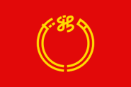
Prefecture flag
Main City: Niigata
Population: 2,177,000 people, ranking 15/47 prefecture (2021)
Area: 12,582 km2
Geographical / Landscape description
Niigata Prefecture stretches about 240 km along the Sea of Japan, from the southwest to the northeast, with a coastal plain between the mountains and the sea.
The prefecture is generally divided into four geographical areas: Joetsu in the south, Chuetsu in the centre, Kaetsu in the north, and Sado Island. The mouth of the Shinano River, the longest river in Japan, is located in Niigata Prefecture. Niigata city is the largest city on the Japan Sea coast.
Climate
Niigata City features a humid subtropical climate. The climate in Niigata City is characterized by its high humidity and strong winds from the Sea of Japan. While many other parts of Niigata Prefecture tend to have heavy snow, Niigata City itself usually receives less due to its low-lying elevation and the shielding effect of Sado Island.
In summer, the south wind makes the weather rather hot.
Recent history, culture
The city of Niigata is now the largest Japanese city facing the Sea of Japan. It was the first Japanese port on the Sea of Japan to be opened to foreign trade following the opening of Japan by Matthew Perry (1854). It has since played an important role in trade with Russia and Korea.
More chapters:
- Economic overview
- Infrastructure
- Living environment
- Major types of economic activities
- Opportunities for EU Investors / Exporters / Importers
- Setting up a business in the prefecture
- Tourism Information


